Tuesday, January 24, 2006

Little Tybee Island


September 2005

Details to follow.

Sipsey River "Turn around" trip

4/23/05 Me, Erika, Brian and Jeannie went to the Sipsey Saturday morning to paddle either from the rec area or from hwy 33. Either trip would require that we take out at 33/Mims. I had talked to a ranger prior to this trip and had inquired about a possible take out about five miles down river from hwy 33. The ranger said it was a good place but that it may require a 4wd to get in and out. He said they hardly ever work that area due to the terrain.The USGS internet site Saturday morning showed the river to be at 85 cfs prior to us leaving home for the drive to Sipsey. Erika and I checked the water level at the Sipsey Rec area when we got there and it showed the level to be below 1 ft at the bridge. I estimated it to be about 10 inches.When checking the level at the Sipsey Rec area we counted about 30 canoes both in the water and preparing to enter the water for an over night trip. Spoke to a woman that mentioned that they were all a church youth group. She said that they planned to do both sections all the way to 278 but that they had SeaDoos scheduled to meet them to pull them out on the "flat" water.This helped in our decision to put-in at Mims and do a turn around trip that would require us to paddle upstream to Mims.We ended up camping right past the first house on the left side of the river in a small slue with a great water falls. Our camp was under the over-hang of the bluff from which the water fell from. This was a great place to camp and included a great fire ring. The seclusion of the place was really nice.We tried fishing a little while but wasn't very successful. Brian M. caught one brim while the rest of us caught nothing. I then decided to do some firewood hunting due to our location not haveing any or access to any. We found a bunch and loaded it into the canoe and paddled back to our camp.Since camp had already been put up we started puting the fire together and getting it going. It was an easy fire due to the good firewood we located. We sat around the fire and had a wonderfull time talking and cutting up. While Brian and Jeannie shared thier "olive medley", Erika shared her Funyuns. I prepared the stove and grill to cook our food. We prepared our shish kabobs for the grill while the corned boiled. Since the grill was so small we had to cook only 6 kabobs at a time. The food was great and we were stuffed.After we stuffed ourselves we continued to talk around the fire and didn't end the evening until around 11:00 pm. The forecast said the low would be in the mid 30's that night and the next morning. I was concerned at how Erika and I would sleep since it was her first time to camp in those conditions. About 5 minutes later (I think) we were both out like lights. It did get chilly but was not at all a problem. When we awoke at about 9:30 am, Brian and Jeannie had already taken thier camp down and packed up for the trip back. I put on some water for hot chocolate and as it was attempting to boil I took the tent down and started packing everything up to catch up with the McClendons. Erika and I had our hot choc and we finished chatting and packing up and begin our trip/marathon trek back.It was definetly a TREK! The current was slack but the wind was stiff at times and a couple of shallow shoals made it semi-difficult to paddle back. The farther we went upstream the more narrow the the river was and that cause the speed of the river to increase. One shoal I had to get out and wade in the water to pull both canoes through. Although we only paddled for about 2 hours it was strenuous at times. During the trek back we ran into the youth group dispersed into various groups. Some of which were being towed by SeaDoos and a Bayliner. For a moment it ruined the peacfulness and serinity of the place. I spoke to a couple of different people from the youth group about the water conditions. The adult I spoke to said that they didnt drag very much and only had to get out one time. This was valuable information for me because of all of the conflicting information about water levels at Sipsey River.Overall I chalked this trip up as another wonderful experience and learning opportunity.

Sipsey Fork - Upper/Lower


Sipsey trip 4/9 - 4/10/05
Left sat morning when usgs reading read 675. When me Barry, and Sharon arrived at the recreation area the wood gage was reading about a few inches above 3'. After returning home and reading the usgs site again the level was at 397 at 4:30 on Sunday. "Hundred Yard Dash" was strong and rocking so we portaged it (about a 200yd portage). That was tough!. The current was flowing ~ 3mph according to the gps. Too fast to enjoy the trip. A couple of spooky strainers as well.

First Sipsey Fork Trip

Saturday, March 19, 2005

From Hwy 33 bridge to 278. Robert and I (Brian) headed out for Robert's first trip ever in his new Zoar. It was my first trip down the Sipsey as well. We both were stunned at the sheer beauty of the place. The steep canyon walls and the over hanging rocks with small streams trickling off into the river. This was totally unexpected and truly a wonderful experience. I was a little disappointed that Robert had to start his first paddle trip in such a wonderful place because everything else in comparison may be boring to him. One of us fell out of the boat while trying to exit the cockpit for a stretch and snack break. I refuse to say who it was due to his size and fear that he may not paddle with me again. Water level was USGS ~150 cfs. It was just right for this section. This section was a total of 11 miles. From the put in at Mims to Sandy Creek was ~4.5 miles. The last 6.5 miles was not as scenic and was very flat. No pics were taken.

Mobile-Tensaw Delta Kayak Trip


Two Rivers Point/Mound Island land-based campsite
Feb. 26th and 27th, 2005
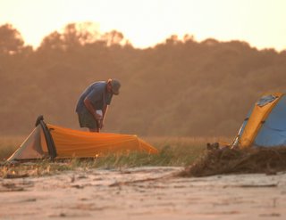
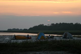
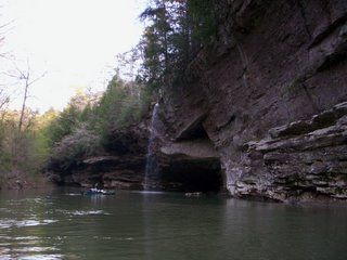
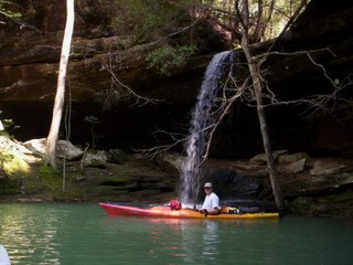
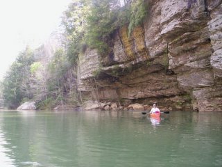
My brother and I left Gadsden Saturday morning, Feb. 26th, around 8:00 AM. We parked at Rice Creek Landing and unloaded the truck around 12:30 PM. According to the Bartram Trail web site, the optimum water level was about 15'-18', while we found it was about 28 ft and hazardous, when we went. Afraid we would run out of daylight following the designated Route 1, we decided to paddle the route in reverse (from Rice Creek to Bayou Jessamine, to Bottle Creek, to Tensaw River, to the designated camp site. We had to paddle up Jessamine in a moderate current and then up Bottle Creek and the Tensaw River, upstream in a strong current which was tough and draining.We were not too impressed with the camping area which looked like a big summer hangout with common beerfest debris. At the campsite, a fisherman in a jonboat, came by and warned us of a potentially dangerous 18 foot alligator on Bottle Creek, which is where we were going again in the AM. We woke up to RAIN!!! The river and creeks had raised another 2-4 inches!!!!! We packed up in the rain and shoved off. The landing area was not kayak friendly.We decided to follow the same route we used on the previous day. Thinking the paddle down river/creek/bayou was an advantage, proved to be a bit risky and VERY tricky. You can imagine how the water can control these long boats- 14' & 16' long. So, we checked out the Indian Mounds on Mound Island, which was absolutely worth the entire messy day 2. It was really unreal!!!! Later, we read there are 18 mounds on that island, many of which we saw. We climbed to the top of the big one (45-50 ft tall). The place was really majestic.We eventually started our strenuous paddle back up Bottle Creek, to get back to Bayou Jessamine. We were relieved to reach the mouth of Jessamine, and thought the rest of the trip would be fast and relaxing. NOT!!!!! About 200 hundred yards in, Chris, my brother, capsized near a stump in chest deep water. He ruined his professional grade $1500 digital camera, although his memory card still works. That incident was a miserable experience for both of us. It was very difficult for him getting back in his boat. Thank God, he bought a bilge pump recently. It was the only way to get the water out.The rest of the trip was miserable, because we couldn't maneuver very well, due to the down stream current and all of the STRAINERS!!!!!!!! It was tough and stressful. We had to portage once around a Z-bend, with multiple strainers. Doing that was a real pain!!!! When we reached the Tensaw River, near Larry Island, I wanted to smile and think the rest of the way was going to be easy, but I was afraid to assume anything more, until we saw the truck.We did make it back to the truck, but had to drive back to Gadsden, in pouring rain all the way. Day 2 was not the best time we have had, but neither of us regret the trip down there. The first day, camping with the barred owls, and the Indian Mounds, were certainly the pay off.